polar stereographic projection
- polar stereographic projection
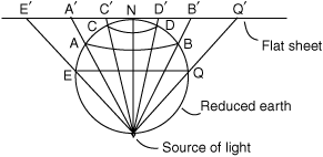
A projection formed by positioning a flat sheet of paper tangential over one pole on the reduced earth and projecting the latitude and longitude graticule onto the paper from a light source positioned at the other pole. In this projection, the scale is correct only at the pole of projection and expands away from it. It has a constant value over the whole chart. Meridians appear as straight lines radiating from the point of projection, and latitudes appear as concentric circles. The rhumb lines are curves concave to the pole of projection. The great circles are also curves concave to the pole of projection except for meridians, which are straight lines that are both great circles and rhumb lines. The projection finds its use in the preparation of plotting, topographical maps, radio aids, and meteorological charts for use in the polar regions.
Aviation dictionary.
2014.
Look at other dictionaries:
Stereographic projection — In geometry, the stereographic projection is a particular mapping (function) that projects a sphere onto a plane. The projection is defined on the entire sphere, except at one point mdash; the projection point. Where it is defined, the mapping is … Wikipedia
Universal Polar Stereographic coordinate system — The Universal Polar Stereographic (UPS) coordinate system is used in conjunction with the Universal Transverse Mercator (UTM) coordinate system to locate positions on the surface of the earth. Like the UTM coordinate system, the UPS coordinate… … Wikipedia
projection — projectional /preuh jek sheuh nl/, adj. /preuh jek sheuhn/, n. 1. a projecting or protruding part. 2. the state or fact of jutting out or protruding. 3. a causing to jut or protrude. 4. the act, process, or result of projecting. 5. Cartog. a… … Universalium
Map projection — A medieval depiction of the Ecumene (1482, Johannes Schnitzer, engraver), constructed after the coordinates in Ptolemy s Geography and using his second map projection A map projection is any method of representing the surface of a sphere or other … Wikipedia
Lambert azimuthal equal-area projection — The Lambert azimuthal equal area projection is a particular mapping from a sphere to a disk. It accurately represents area in all regions of the sphere, but it does not accurately represent angles. Intuitively, it gives a planar picture of the… … Wikipedia
Collocation (remote sensing) — Collocation is a procedure used in remote sensing to match measurements from two or more different instruments. This is done for two main reasons: for validation purposes when comparing measurements of the same variable, and to relate… … Wikipedia
Primitive equations — The primitive equations are a set of nonlinear differential equations that are used to approximate global atmospheric flow and are used in most atmospheric models. They consist of three main sets of equations: # Conservation of momentum :… … Wikipedia
3-sphere — Stereographic projection of the hypersphere s parallels (red), meridians (blue) and hypermeridians (green). Because this projection is conformal, the curves intersect each other orthogonally (in the yellow points) as in 4D. All curves are circles … Wikipedia
Geographic coordinate system — Map of Earth showing lines of latitude (horizontally) and longitude (vertically), Eckert VI projection; large version (pdf, 3.12MB) … Wikipedia
Complex plane — Geometric representation of z and its conjugate in the complex plane. The distance along the light blue line from the origin to the point z is the modulus or absolute value of z. The angle φ is the argument of z. In mathematics … Wikipedia